Thursday, November 2, 2023

Camden natives: an uncomfortable conversation

November is Native American Heritage Month. What started at the turn of the century as an effort to gain a day of recognition for the significant contributions the first Americans made to the establishment and growth of the U.S., has resulted in a whole month being designated for that purpose and a proclamation from George H. W. Bush in 1990 calling upon “Federal, State and local Governments, groups and organizations and the people of the United States to observe such month with appropriate programs, ceremonies and activities.”

We have some catching up to do here in Camden, but we are so far behind that it seems no one knows where to start.

I’ve been thinking a lot lately about Camden natives, and what it means to be one. Terms like Camden native and “from away” get thrown around in political disagreements about things like sidewalks and school funding, but the fact is that most true Camden natives were driven out long ago. I’m not talking about the ones who moved to Union to get away from all the hippies who moved here in seventies and eighties. Their families may have been here a few generations more than others, but it’s all pretty inconsequential in terms of the history of the land we inhabit, where a culture and ecosystem endured and evolved for thousands of years before us.

In the same spaces where we squabble about tourist attractions, parking spots, picnic tables and honoring our history, a larger story and a longer history hangs heavy. The things that we call historic are but tiny blips in the story of the land we occupy, the Megunticook River Valley, carved out between mountains by the receding glaciers some 13,000 years ago and populated by the people whose memory lives only in the names of a few of our favorite places. This is the ancestral hunting and fishing territory of the Penobscot and Abenaki people, and their traces can still be found sprinkled among the ashes and buried in the mud.

Camden’s first permanent European settler, James Richards, is said to have sailed into Megunticook Harbor with his family 253 years ago. The details of this era in Camden history are poorly documented and leave much to the imagination, but it’s often where the telling of Camden’s history begins and we’ve fallen into the habit of repeating as fact the misstatements. We tell our kids that Mount Battie was named after Betty Richards and that Negro Island (later renamed Curtis Island) came from a comment made by the unnamed African cook who arrived with Richards and his family. 

Really? Camden’s first settler was a slave owner? Did they all have slaves? If so, where are they buried? Very little has been documented that supports the fable, but still it is repeated. All of Camden’s serious historians, most of them from away, have noted how poor the record keeping was among the early Europeans. They were just trying to stay alive and struggled to keep track of their own history, never mind document what came before them.

George Weymouth, who is known for his early explorations of Penobscot Bay at the beginning for the seventeenth century, came at a time when a great number of indigenous people still lived here. In his efforts to colonize the land, he kidnapped several of the natives and brought them back to England. If only we could have convinced him of the great value it might have been to just leave them alone and learn the history of our beloved region through their eyes. What stories did they tell their children? What secrets had the mountains revealed to them? Beautiful paintings have memorialized Weymouth’s voyage and his ship, the Archangel, but how have we remembered the people that he disrupted? The question is a nagging one that has come up before, but not often enough in Camden.

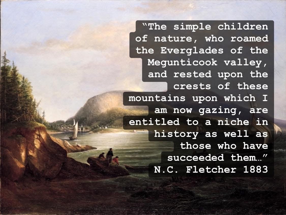
The following is from a column by Nathan C. Fletcher published in the Rockland Opinion in 1883 (credit goes to Barbara Dyer for the fact that anyone knows about Fletcher’s writing at all). His son built the building known as the Fletcher Block about 10 years later (now home to Boynton McKay). In a series of columns for the newspaper he commented on the many inaccuracies and omissions in the town’s historical record, and produced what might be considered Camden’s first and only land acknowledgment statement.

“The Indians in great numbers met Captain Weymouth and his company, when they landed upon our shores, in a friendly manner and brought their furs to exchange for trinkets of but little value; and the Englishmen repaid them by invading their humble wigwams, and wrenching from the mother’s fond arms the best beloved boy, and from the father the girl, the delight of his eyes, who cheered him in his lonely hours in his embowered wigwam, when returning from his hunting grounds. The simple children of nature, who roamed the Everglades of the Megunticook valley, and rested upon the crests of these mountains, upon which I am now gazing, are entitled to a niche in history… I have been led to speak of those who preceded us in peopling these regions, when Camden was a solitude, as was the group of islands before me; which gracefully rest upon the peaceful waters of ‘Penobscot bay,’ as an act of simple justice and to leave on record my utter detestation of the villainous conduct of those freebooters…”

I have found nothing so strongly worded in any historical writing or commentary since Fletcher and if anything, our view of history seems to have condensed rather than expanded as a community. In Camden, honoring our history is mostly about the last hundred years or so, and even then, the emphasis is inconsistent and the oral histories are foggy and often contradict the source documents. The word historic, in Camden seems to evoke notions of dazzling homes on Chestnut Street or flower pots hanging from lamp posts…. We talk about the Village Green, the library, Harbor Park, all of which were designed less than 100 years old.

Even the story of James Richards and the struggle to survive has mostly been omitted from the narrative, but at his time there were still a few of the Wawenock tribe living in the area and although they are said to have coexisted peacefully with the new settlers, we don’t know much other than they would sometimes come and use the sharpening tools outside his doorstep.

According to Camden’s earliest history book, a few sites during James Richards’ time were said to have still been occupied by the Wawenocks. One of these was Eaton’s Point, as it was called. It is still a place notable as a landmark in the general vicinity in front of the condos in between Lyman Morse and Steamboat Landing. There is sizable boulder there too that once defined the northern boundary of Camden and it can still be seen right where the surveyor said it was in 1768 (I’m about 85% sure), cast down from the mountains by the receding of the glaciers and no doubt employed as a waypoint for thousands of years before us. Our deepest connection to history is looming large above us in the mountains, scraped in the bedrock by glaciers, buried in the soil beneath our feet.

A few people like Kerry Hardy and Harbour Mitchell have done more than most to prod us into more careful examination of our past. In many cases, a better understanding of the natural history of the region is the best starting point. The remnants of clam flats have been found in the soils at the outlet of Megunticook Lake, reminding us that all of Camden was once an ocean. Arrowheads along the banks of Dailey Brook and the early maps speak to a time when Camden Harbor’s intertidal zone extended nearly all the way to Route 1. The shape today is the result of a combination of dredging out of native clam flats and the importing of soil to fill in around the edges. Most of our streams have been dammed or blocked with culverts, so radically altering the habitat as to render them unlivable for many native species like Brook Trout.

Still, there are a few places that true Camden natives can be found hiding out in the cold waters that descend from the mountains, cascading naturally over the rocky ledge that connects us with the true native people of the region.

In the vicinity of Quarry Hill, Don Rainville and his wife Michelle stumbled upon some of Camden’s most ancient artifacts, some dating back 5-7,000 years, during a renovation to their home on Camden Street. Thankfully, they knew they had stumbled on something special and have taken on the burden of proceeding slowly with any new excavation, painstakingly inspecting and documenting their findings.

How much of Camden’s history is destroyed or unnoticed simply because we haven’t trained ourselves to look for the more subtle signs? If we value our history, we must learn to look for it and reflect honestly, not just in the concrete walls and brick buildings we’ve trained ourselves to recognize as historic but also the layers of soil, the wildlife, the bedrock, and the water that flows from all around.

Sunday, September 10, 2023

Private piers and public trust


I’ve been trying to write as much as possible about Camden’s public access points to the harbor before I forget what it felt like not to know about them. They are easy to ignore when not enough people know they exist, so it’s great to see the new signs marking many of the lesser known spots like Eaton Avenue, Harbor Road, and the Curtis Island Overlook. We are still waiting on signage at Sherman’s Point Road. 

It’s notable that many of the public access points contain the word “overlook”. It’s meant to make it clear that there is no obvious way to get down to the water—whether natural or engineered— but at each of these locations, the public rights goes all the way to the low tide mark. The adventurous and the physically fit are free to descend at their own risk. Everyone else is encouraged to request that the town prioritize safe ways to reach the shore at our public access points. 

But you should also know that public rights to access the water extend beyond the official boundaries of the town owned land. They go all the way back to the 16th century when Queen Elizabeth recognized the public’s “inalienable right to the sea” and the public trust doctrine was established. It’s a somewhat complicated issue and case history in Maine, but in essence, it established that certain lands are held in trust by the government for public benefit. 

Specifically, tidal waters and submerged lands belong to the state and cannot be sold to a private party. The public has the right to cross over “unimproved land” in order to access a great pond or tidal waters. Maine’s beaches or intertidal areas influenced by the ebb and flow of the tides are often privately held by the upland property owner but the public has a permanent right of way to access the land for the purposes of “fishing, fowling, and navigation” all broadly defined. 

Maine has been mulling through case after case determining the evolving meaning of “fishing, fowling, and navigation” as it relates to the economic and recreational realities of today. For those who want to know more, I recommend an article published by the Ocean and Coastal Law Journal (2020) titled Access for the Future: Improving Maine's Implementation of the Public Trust Doctrine through Municipal Controls to Ensure Coastal Access for Continuing Benefit to Maine's People and Economy by Allison M. Kuhns

https://digitalcommons.mainelaw.maine.edu/cgi/viewcontent.cgi?article=1392&context=oclj

Private land owners frequently attempt to keep the public off of the beaches in front of their properties, and court cases have delved into the details of creative applications of allowed uses. For example, crossing over a private beach to reach the ocean for scuba diving is a right under the public trust doctrine and so is digging for worms.

In many places, the private property owner’s right to access the water from their property has taken the form of private piers and docks, which in turn, interferes with the public’s right of passage. Some docks are required to have a set of public stairs that allow for passage above the structure when the tides are such that passage underneath is not feasible. 

Piers also displace habitat for shorebirds and shellfish. Wading birds have been found to avoid a 300ft radius around pier structures. The pilings associated with the structures permanently consume real estate used by clams and other shellfish. 

Most of our harbor access points are sandwiched between private property, sea walls, piers, and man-made precipices meant to keep the adjacent properties from losing any real estate to the sea. In some cases, the private property owners even managed to convince the townspeople to share in the cost of building the erosion control sea walls that protect their property while creating a virtually impassable vertical drop for the public access point. 

We forget that beaches are formed by the natural process of erosion. As sea level rises, the beaches and intertidal zones will migrate landward in some places where they are able to. In other places, constructed sea walls (often built in conjunction with private piers) will keep the shoreline in a fixed position, shrinking the amount of dry beach that will be revealed on the outgoing tide. 

This phenomenon is referred to as coastal squeeze and you can feel it at high tide if you try to walk anywhere along the beach in Camden Harbor. In some places, the footings of a private pier actually occupy the only spot that would allow a pedestrian to pass by at certain tides. 

When I was first elected to the Select Board, I avoided taking positions on issues relating to boats and harbor infrastructure since it was clear to me that I have a lot less experience than many of my friends and neighbors. Being surrounded by family members who have spent their professional careers working in this area has prepared me well for the habit of deferring to the input of others on this topic. Even my kids are more proficient in basic marine vocabulary than I am, but there’s something liberating about accepting your role as an observer in need of learning from others. 

This may be one of the reasons that so many people reach out to me with their own questions and concerns regarding the harbor. I’m not embarrassed by not knowing the answer and it’s easy for me to be open minded and ask my own questions. People have rightly assumed that I might be convinced to see things their way on certain topics because I haven’t established a rigid position of my own. 

I’ve done a lot of listening about “the way things used to be” and all the public access that has been lost. There was a time when Camden Harbor wasn’t as popular as it today and it was viewed more like an airport and less like a destination of its own. Allowing some private property owners to build structures through the public trust resources didn’t seem like such a big deal if it was only a few piers and everyone who wanted a mooring in Camden Harbor could get one. 

Today, every inch of Camden Harbor is potentially precious real estate. I do not anticipate personally wanting to have a boat moored in Camden Harbor, but I have many friends and family who pay fees every year just to be on a waiting list for the privilege. Demand is growing all the time. The Harbor itself is a destination for many and the economic importance that was linked to sustenance fishing in Queen Elizabeth’s day may look more like guided fishing and photography trips today.

One place you can see the changing pressure for space in the harbor is at the dinghy dock. Traditionally, the dinghy dock was for people to park their small boat which would get them out to their bigger boat, but a new class of boaters has emerged that is rapidly encroaching on the dinghy real estate. We are broadly referred to as paddlers and many of us are happy to never leave the harbor at all. Smaller vessels are supposed to get out of the way of larger ones but in Camden Harbor there is a single established channel. A trip over to Sherman’s Cove is magical by paddle board if you hug the shoreline and gaze at the rockweed but sooner or later one of the massive private piers will force you out into the main channel to compete for space with launches, tenders, schooners, and more. 

Sometimes I go down to check on my little dingy and I become so enamored with fish and underwater flora and fauna that I never even leave the dingy dock at all. The harbor to us is not a launching point to get us out onto Penobscot Bay but a destination all its own. The intertidal habitat, the changing tides, the beaches, and the estuarine waters where Megunticook and other small streams mix with the sea provides an experience that attracts anglers, tourists, shell collectors, beach walkers, paddle boarders and even swimmers. 


Until recently, shellfish harvesting in Shermans Cove and other swaths of Camden’s mud flats was an activity that drew both hobbyists and the hungry down to the harbor, but the concerns over pollution within a certain radius of wastewater treatment plant outfalls has closed the area for now. This has opened up for door for new pier applications to say with a straight face that they won’t interfere with any existing shellfish harvesting, but shouldn’t we be looking for ways to eventually reopen the shellfish harvest rather than allowing more private structures on the grounds that we already polluted the water too much for certain types fishing?

With so many missed opportunities to look back on, let’s not miss our opportunity to keep the keys to the castle that remain. There may come a time when we need or want to build commercial or public use piers, docks, and even breakwaters. As sea level rises, the water may become deep enough in some places to support new moorings and we have an obligation to safeguard precious public resources now rather than give them away to private interests. We can always go back and decide to give more of it away to private development if we choose to later but it doesn’t work the other way around. 

In 2015, the harbor committee and the planning board unanimously recommended a ban on new private residential piers but the Select Board voted in a split vote not to pass the question on to voters. It’s time to make that happen.

Building over the Megunticook River

After my sister died in 2018, I was a mess. And the two coping mechanisms that worked best for me were filming fish underwater and digitizing old town records. I’ve always been kind of a nerd. One of the projects I took on was digitizing the old Camden Select Board meeting minutes from the 1930s. Although they lack detail, there are many interesting tidbits that remain relevant today and the cartoon in last week's paper got me thinking about Main Street. 


At the May 18th, 1931, meeting of the Camden Board of Selectmen, a letter was read that had come from the woman who donated most of the land for Camden’s library and adjacent park. The minutes from the meeting include only these words: “Letter from Mrs. Bok regarding building over river, read.” Mary Louise Curtis Bok hired and worked closely with the famed Olmsted Brothers to do the design work for this and multiple other locations around Camden and Rockport.

I always wondered. Did she want to build something over the river? Did she want to improve the buildings already there? Something else? I filed it away for a time when I would have more context, but anyone reading those minutes at the time would have had a pretty good idea. Now that the Camden Herald has digitized so much of their archive (actually credit goes to the Camden Public Library, not the newspaper), it’s clear Mrs. Bok was not a fan of allowing the river to be hidden under buildings.

The discussion had been going on for a few years, ultimately prompting a Camden Herald Editorial in the August 23rd 1928 edition in response to a presentation given by Edward Bok (the husband of Mrs. Bok) and Dr. Charles Codman (think, Codman Island on Megunticook Lake) which encouraged the townspeople to value the fact that in Camden we “have the greatest gifts of nature” but have allowed “a beautiful mountain stream, flowing right through the very heart of the town to become a foul cesspool, hidden from view by a few buildings.”

The editors of the paper agreed:

“Dr. Charles Codman, at a recent Board of Trade meeting, pointed out the fact that the river flowing through the town as it does, is not a sanitary or desirable thing. Moreover, we are wondering whether it is lawful for any town to allow the placing of buildings on spiles over a public stream in such a manner as to clog the stream, catch waste and sewage, and hold it. A few years ago, we had a heavy flood and the first place that clogged and gave rise to serious danger was the main Street bridge with the buildings across it.”

They were referring to the devastating rain storm of 1922 which swept at least one Main Street building and many bridges into the river. Dean’s stable — which used to be sandwiched in between the House of Logan and the Leather Bench — gave way, drowning one horse and nearly the rest of them. Most of the Main Street businesses were flooded and the recovery effort required the cutting open of the bridge on Main Street where debris was trapped.

As Mrs. Bok worked with the Olmsted Brothers to design Harbor Park, she slowly removed every building existing on the parcels she owned, but the park design also required working around private property, including the dam. At that time, what we know as Montgomery Dam was all part of a larger parcel that included most of the buildings on Main Street. Over time, the owner of that parcel had leased out space to proprietors of businesses that wanted to perch their buildings over top of the river to gain store frontage on Main Street. 

The 1912 edition of the Sanborn Fire Insurance maps shows multiple buildings in Harbor Park that have since been demolished, and three fewer buildings over the river on the harbor side than there are today.

Eventually, each of these new buildings became separate parcels.

But before that, on June 23rd, 1931, a special town meeting was held at the Engine Hall “for the purpose of granting authority to the Board of Selectmen to invoke condemnation proceedings with regard to certain wooden buildings now located on the Main Street bridge.” The paper reported that the meeting “was well attended by a representative group of citizens… The vote was unanimous, there being no dissenting voice raised.”

On July 1, 1931, the municipal officers of Camden gave notice of their intention to take, “for public park purposes”, the land over which was situated the Stratton fish market and the Drinkwater Garage. But it wasn’t all about Mrs. Bok and her vision for restoring the view of the harbor from Main Street. Plans were underway for replacement of the Main Street bridge — then owned by the county — and the Town had been told that work could not proceed until the buildings were removed.

August 1931, Mrs. Bok stated she hoped that someday the buildings which now rested directly over the falls on Main Street, hiding their beauty, would be removed, and a new artistic bridge erected on Main Street. In the same issue of the Camden Herald, the editors opined over “what a treat it was to hear from Mrs. Edward Bok herself” on the project underway at the Camden Public Library lot and that “many a rumor was put to rest by Mrs. Bok’s keen and masterly appreciation of the fine points of the scheme from the architectural and community standpoint.”

They went on saying “we agree with many of the suggestions that Mrs. Bok set forth, namely — the removal of the buildings from over the stream:—the diversion of waste, etc., into direct sewer lines to the harbor — a new bridge over the stream that shall be a thing of beauty for Camden. We hope that these suggestions will come to pass.”

It’s not clear what happened next, but it appears that compromises were made on the bridge design, and the buildings were allowed to stay. The compromise has involved a delicate balancing act where the water level is raised to improve aesthetics and then lowered as needed to work on the buildings and bridge. The Megunticook River is visible from only one spot on Main Street and so it’s easy to lose perspective of its course as it disappears beneath a labyrinth of bridge piers and building supports before re-emerging on the other side of the Smiling Cow (the former Drinkwater Garage).

The way the buildings and the bridge are designed requires that the water be lowered in order to perform a variety of maintenance tasks. When the flow is at low to moderate levels in the river, the pool underneath the Camden Deli can be drained by opening up the gate on the Montgomery Dam and letting water out the sluiceway into the harbor.

During the May 1st storm, logs and debris got caught in the bridge and the buildings, and had it been worse, we may have gotten a taste of what they saw in 1922. One of the purposes of the early dams was to help float logs over long distances, and the Montgomery Dam in the closed position facilitates floating of debris, which then has to pass through narrow openings of the support systems for the bridge and buildings. This is one of the reasons why modern bridges give rivers more room with wider spans and no center pier if possible.

Luckily, a few days after the storm, the pool under the bridge and buildings could be drained in order to make it possible for MDOT to pull things out with a boom truck. The same thing happens when one of the building owners needs to paint, fix their footings, or make other improvements. Sometimes, additional water must be held back from the lake in order to make this possible.

Unfortunately, draining the pool reveals a scene that is cringeworthy under the bridge and buildings. A derelict fuel tank, impounded sediment, hanging wires, fallen plumbing, sunken timber and collapsed piers. It’s not clear who is responsible for all the stuff, but everyone usually agrees it looks awful enough that they request to fill the pool again as quickly as possible. Out of sight out of mind.


Almost 100 years after Mary Louise Curtis Bok proposed a more aesthetically pleasing bridge on Main Street, we are no longer generating power at the site, but we are still treating this section of the river more like a canal than a beautiful mountain stream. No matter what happens with the dam, we can't put off cleaning up the mess underneath forever.

Communities are wrestling everywhere with the collective responsibility to clean up their waterbodies and remove debris to prevent flooding. Luckily, we are at an unprecedented moment where federal funds are available to improve all of it and the funds can even be used to help improve the support structures under the buildings so they are resilient and aesthetically pleasing.

I am so curious as to what Mrs. Bok would have envisioned for a bridge on Main Street now that it is once again due for replacement. Was she imagining something like what we have on Knowlton Street or near Megunticook Market or would it have been more like the arched granite of some of the other Olmsted parks?